Railinc has launched its new RIGIS Routing + Mileage application. The tool delivers accurate rail routing and mileage data across North America.
Railinc developed the application in partnership with industry stakeholders. It runs on the Rail Industry Geographic Information System (RIGIS) Network, which supports routing, mileage, and other critical rail applications.
RIGIS serves as the central source for rail locations and mileage data. It provides consistent information for regulatory reporting, financial settlement, and safety planning. Shippers, car owners, railroads, and emergency responders all benefit from the system.
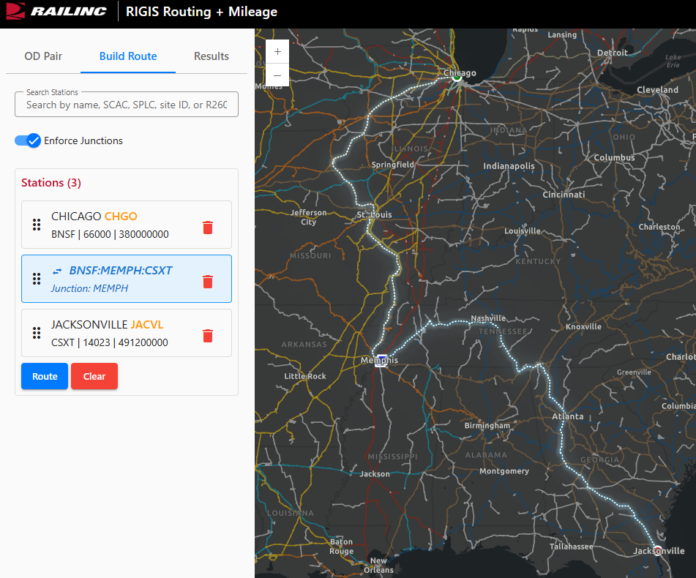
Railinc reviewed, updated, and standardized data across tens of thousands of rail network locations. The application lets users visualize and analyze routes with precision. Users enter an origin and destination to view carriers and see mileage by state. They can also select preferred carriers or create custom routes with multiple locations. The system allows users to specify interchanges at exact junction points.
The platform includes a highly scalable and reliable API. It maintains performance even under heavy demand.
“This sets a new standard for location identification and mileage calculation,” said Brent Kastor, Senior GIS Manager at Railinc.
The Association of American Railroads (AAR) GIS Committee and Railinc led the project. Teams validated and resolved data discrepancies across North America to build a single, trusted dataset.
The application improves data quality and ensures consistent mileage results. It updates station data as networks change and recalculates mileage automatically. Railroads now have one authoritative source for routing and distance data.
The system also reduces cost and complexity. It simplifies integration and eliminates duplicate effort. Users can plug the API into their own platforms and display routes using open-source mapping tools.


